The city in South Asia
James Heitzman
Heitzman, James;
The city in South Asia
Routledge, 2008, 283 pages
ISBN 0415343550, 9780415343558
topics: | india | south-asia | history | urban
Excavations at Mehrgarh provided convincing proof that the rise of agriculture was not the result of diffusion from the west but originated in South Asia (Jarrige 1995).
Excerpts
Few appreciate the antiquity of the agrarian and urban settlements represented by these mute mounds which people today plough and plant with crops, pillage for soil and bricks, or tread when they cross their doorsteps. Even the first modern historians of South Asia, while cognizant of the archaeological material lying near at hand, subordinated physical culture to textual analysis. During the nineteenth century, when British scholars oversaw the assembly of the historical disciplines, the model for archaeological reconstruction was to begin with references in textual sources and then correlate them with information gleaned through ground surveys and excavations. The most important chronological baselines were the ministries of Gautama, who established Buddhism, and his immediate predecessor, Mahavira, who promoted Jainism; information gleaned from the texts associated with their religious traditions suggested that these men lived around the middle of the first millennium BCE. The first Director of the Archaeological Survey of India, Alexander Cunningham (1814–93), enjoyed considerable success in following references from such textual materials, or from travel accounts such as that of the seventh-century Chinese monk, Xuan Zang, in order to identify specific mounds with places appearing in literary sources. The early results of this research clearly indicated that a society of considerable urban complexity and sophistication existed in what are today northern India, Pakistan, and Bangladesh about 2,500 years ago. ...
Harappan or Sindhu-Sarasvati civilization
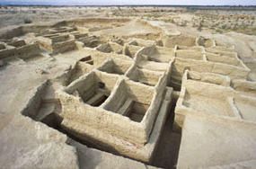
Early layer from Mehrgarh, c.7000 BCE. walls are
built with mud bricks. [source:wiki-commons]
The first structured excavations during the 1920s at Harappa and then at Mohenjo-daro yielded artifacts that resembled items uncovered during contemporary excavations in Iraq (old Sumer) dated to the third millennium BCE. These discoveries stimulated the growth of an entirely new field in South Asian archaeology dedicated to the study of what came to be known as the Harappan (after one of its most important sites), Indus Valley, or Sindhu-Sarasvati Civilization (after the two major rivers along which its sites clustered). The nomenclature of civilization applied to this extensive archaeological complex derives not only from its literate or proto-literate character but also from the indisputably urban character of its major sites.
Mehrgarh: contemporary w Jericho and Catal Huyuk
Excavations during the 1970s and 1980s at Mehrgarh in Baluchistan provided
convincing proof that the rise of agriculture and village life, evolving into
more complicated forms of urbanization, was not the result of diffusion from
the west but originated in the creativity of South Asian peoples (Jarrige et
al.  1995). Mehrgarh lies at the foot of the Bolan Pass, along an ancient
trade route allowing travel to the highlands of Afghanistan and Iran and also
to the plains of southern Pakistan, with relatively easy access to a variety
of ecological niches.  Archaeologists discovered here a continuous record of
habitation dating back to a pre-ceramic culture in the early-seventh
millennium BCE which
makes this site contemporaneous with Çatal Hüyük in Turkey (Mellaart 1967)
and Jericho in Palestine (Kenyon 1970), several of the world's oldest
known settlements.

At that point the inhabitants of Mehrgarh were already constructing
permanent structures of mud bricks including houses and storage facilities
designed to preserve barley, gathered by semi-nomadic groups using flint
sickles and relying on hunting for part of their subsistence. The
subsequent story of this site includes the evolution of increasingly
sophisticated ceramic technologies, domesticated animals and more permanent
settlement structures.

By the late-fifth millennium the inhabitants utilized copper, manufactured
wheel-thrown pots, and produced artistically fired beads. By the
fourth-third millennium BCE, permanent settlements and cultivation,
possibly with irrigation facilities, had replaced traces of seasonal
habitation. Wheat and grapes were important crops.

Traces of large-scale pottery production suggest the presence of a
multi-site marketing system. Large numbers of terracotta human forms appear
in and around house sites. Extensive terracing and large retaining walls
indicate a movement toward monumental public architecture.  Trans-regional
trade seems to have been important at Mehrgarh even from its earliest
phases (revealed by the presence of shell ornaments coming from the ocean,
500 kilometers distant). The later phases of occupation link directly with
nearby sites such as Nausharo yielding Harappan artifacts, thus providing a
sequence from the very beginnings of settled life through the first urban
urbanization in South Asia.

Archaeologists have identified hundreds of sites where pre-Harappan village
farming communities developed the complete range of technologies (including
traces of monumental walls) that would give rise to Harappan urbanization.
In addition to Mehrgarh four such artifact assemblages have been identified, each
associated with their primary sites: Amri and Nal; Kot Diji;DambSadaat; Sothi and
Siswal (see Map 1). Investigators now describe a pre-Harappan period beginning
in the late-fourth millennium BCE, when changes were occurring within multiple
cultures that prepared the ground for the complexity of the mature Harappan
phase between 2600 and 1900 bce. The transition to the mature phase seems
to have occurred rapidly, perhaps within only a few generations (Possehl 1999;
2002: 50–3).
Geographical Spread
More than 1,000 sites display the cultural characteristics that we
associate with the mature Harappan Civilization. They exist in all parts of
Pakistan south of Kashmir, in Gujarat, Haryana, Jammu, Punjab, and
Rajasthan in northwestern India, and even along theAmuDarya in northern
Afghanistan. Most of the locations remain small, constituting village
sites; if the average size of settlements during the early Harappan phase
was 4.51 hectares, it increased to only 7.25 hectares during the mature
phase (Possehl 1999: 555). The largest sites, however, are quite big. They
include Mohenjo-daro (with a city core of about 100 hectares, and suburbs
possibly covering more than 200 hectares) in Sind; Harappa (more than 150
hectares) in the center of Pakistani Punjab; Dholavira (between 60 and 100
hectares) in Gujarat; Ganweriwala (82 hectares) in Pakistani Punjab near
the border with Rajasthan; and Rakhigarhi (between 80 and 105 hectares) in
Haryana (Smith 2006: 109).

The region called Cholistan, lying in the southeastern part of Pakistan's
Punjab province, is among the most thoroughly explored regions of the
Harappan civilization. Today this is an arid ecosystem, a northwestern
extension of India's Thar Desert, but ground surveys and aerial photography
reveal that a major river system once flowed here. Between 3,500 and 1,300
bce there was enough water to support a flourishing complex of village
farming communities evolving into a four-tier hierarchy of settlement
sizes. During the first centuries of occupation, nomadic occupation roughly
balanced the number of more permanent agricultural settlements. By the time
of the early Harappan phase (3100–2500) permanent settlements comprised 92
percent of all extant sites while nomadic campsites had shrunk to only 7.5
percent. After 2500, during the mature phase, out of 174 identified sites
(most of them small villages) 45 percent were purely industrial locations
for the production of bricks, pottery or metal objects while 19 percent of
habitation sites also included kilns for commodity production. During this
phase Ganweriwala, the pinnacle of the settlement hierarchy, became two
closely associated mounds, today rising to a maximum height of 8.5 meters
above the plain. After 1900 there was a dramatic drop-off in the number of
sites and purely industrial zones, suggesting that the settlement complex
was collapsing with the disappearance of the river system (Mughal
1997). The Vedic hymns preserve several references to the existence and
subsequent disappearance of the Sarasvati River, corroborating a theory of
radical transformation in this ecosystem by about 1300. The Cholistan
surveys reveal, therefore, a complete sequence: the rise of village farming
communities; the elaboration of more complex settlement hierarchies; and
occupational specialization leading to urban growth and subsequent decline.
City plan: Mohenjo-daro
Mohenjo-daro, perhaps the most important archaeological site in South Asia,
excavated repeatedly since the 1920s (Marshall 1931), provides a detailed
view of a primate city during the mature Harappan phase, including monumental
constructions within a ‘high’ town or ‘citadel’ to the west, and habitation
areas in a separate ‘low’ town of greater extent to the east. The
northeastern portion of the citadel mound rises 13 meters above the plain and
is the location of a Buddhist monastery dating from the early-first
millennium ce that was constructed on the more ancient tell. Earlier British
scholarship, never far from a military interpretive framework, described
massive brickwork visible on the edges of the citadel as the remains of
fortification walls (Wheeler 1968: 29–31, 40, 72–7).  Hundreds of soundings
on the mound have indicated, however, that its height is not part of a
fortification scheme, nor is it simply the result of accumulated debris, but
is a planned feature; before occupation occurred, a mobilized workforce had
constructed massive retaining walls for a giant foundation that raised the
bases of buildings 5 meters above a plain flooded regularly by the nearby
Indus. The citadel mound has yielded the most impressive architectural
remains – all constructed of mud or burnt bricks – found in any mature phase
settlement. These include the Great Bath, perhaps the most photographed of
all Harappan monuments: a watertight pool measuring 12 meters north-south and
7 meters east-west, capable of retaining 140 cubic meters of water. Water
came from a well in a room on the east and outflow went through a drain
consisting of a 1.8-meter-high drain roofed with a corbelled vault. The water
was accessible by a stairway on the north side of the bath. Brick colonnades
that probably supported a wooden superstructure, including screens or window
frames, surrounded the bath. A public street enclosed the entire complex. The
‘granary’ to its west consisted of a foundation measuring 27 meters north to
south and 50 meters east to west divided into 27 brick plinths, in nine rows
north to south and three rows east to west separated by passageways, that
once supported wooden pillars or beams. An ‘assembly hall’ or market in the
southern part of the citadel mound featured 20 brick foundations arranged in
four rows of five each. More public buildings seem to lie under the Buddhist
monastery.

On the eastern mound or ‘low’ town, which also may have rested in part on a
massive artificial foundation (Dales 1965: 148; Jansen 1978), the most
extensive horizontal excavations of any Harappan site have revealed the plans
of contiguous habitation blocks. Several boulevards running roughly
north-south (including a wide thoroughfare named ‘First Street’ by the
excavators) provided a means of walking directly through the entire
settlement. Smaller, parallel lanes ran north-south for shorter distances,
intersected by other smaller lanes running east-west – a generally cardinal
orientation. Obvious differences in house sizes and layouts betoken distinct
gradations in class or status. In the northeastern habitation block a large,
coherent complex of rooms demonstrates an unusual sturdiness of construction,
perhaps evidence of a major public building, while another complex was
labeled a ‘palace’ by the excavator (Mackay 1938: 41–70, 148–51).

Building interiors were invisible from the street, but entrance to a
household compound would present the visitor in some cases with a courtyard
surrounded by rooms, or in other cases with a simple cooking and sleeping
area in one or several rooms. The remarkable preservation of house walls
suggests that windows, if present, existed high on the walls; examples of
artworks showing windows indicate that wood may have been the primary
component in window construction and ornamentation (Kenoyer 1998:
57–8). Roofs, undoubtedly flat, were probably constructed of wooden beams
(spans seldom greater than 4 meters) and mud plaster. Some remains of
stairways at this and other sites demonstrate that people had access to
their roofs. There is clear evidence of delineated bathing areas within
homes, especially some of the larger units; outside, carefully constructed
brick drains running through public space intersected with pipes coming
from homes to draw sewage out of the city and into sumps that could be
dismantled for periodic cleaning (Jansen 1993). Water supply for the entire
city came from an estimated 700 wells. With the possible exception of the
elaborate drainage systems, the plan of the residential area at
Mohenjo-daro and the hypothetical reconstruction of house architecture
demonstrate close similarities to housing types still used in this part of
the subcontinent.
Harappa, Kalbangan Dholavira
The plan of Harappa, where excavations started slightly earlier than at
Mohenjo-daro, includes an alignment of two main mounds (excluding the area
of the modern village, which lies above another section of archaeological
remains) on massive retaining walls and basements pierced on at least one
side by a gate.  At Harappa one finds another ‘granary,’ or two blocks of
parallel brick basements that seem to have supported a wooden
superstructure covering an area of 46 by 17 meters. At the site of
Kalibangan along the bank of the former Ghaggar River, once again we find
two distinct mounds: a heavily fortified section in the west measuring 120
by 240 meters, containing possible ceremonial platforms; and a separate,
fortified area to the east measuring 240 by 360 meters encompassing
habitation areas. If Harappan urbanization up to this point seems to
demonstrate a standard plan, juxtaposing high-status public space in the
west with a lowerstatus but differentiated population living in the east,
town planning from other sites produces a more variegated pattern. At
Dholavira, for example, a larger enclosing wall with bastion-flanked
gateways encompassed a ‘lower’ town and a walled ‘middle’ town in turn
flanked by a smaller, fortified ‘castle’ and adjoining ‘bailey.’ At the
smaller sites of Banawali and Surkotada, a single outer fortification
surrounded two subsidiary divisions separated by bastioned walls with
gates.  It appears, then, that the Harappans were concerned about issues of
security and mobilized labor resources to establish spatial segregation
within their settlements, but the architectural alignment varied widely
from one site to the next. There were shared concerns, but not standard
templates, in the careful planning of their towns (Chakrabarti 2004).
Food, Agriculture, Trade
A crop package of wheat, barley, lentils, peas, chick peas, and flax
was well developed by the late-third millennium bce. Several species of millets
that originated in Africa (sorghum or jowar, finger millet or ragi, pearl millet
or bajra) seem to have reached South Asia by the early-second millennium
bce. Other millets and fruits, the Bactrian camel and the horse arrived from
Central Asia. At most sites, a substantial proportion of the population must
have made their livelihood raising sheep, goats, and cattle, or interacted with
nomadic or semi-nomadic groups specializing in the care of animals (Weber and
Belcher 2003).

The site of Lothal in Gujarat provides some clues concerning the organization
of trade routes that made possible the movement of goods at the regional level
or between South Asia and points west. This small center (4.8 hectares) seems
to have served as a warehousing or trans-shipment point complete with an
artificial harbor and quay. A seal found here came from Dilmun, the name used
in Sumerian records for the area around Bahrain in the Persian Gulf. Sumerian
sources describe trade with Dilmun but also mention Meluhha, a term denoting the
Harappan cultural region. It seems that commercial groups from Meluhha settled
down in Mesopotamia for extended periods during the late-third millennium.

Archaeological work in Oman and between Dubai and Abu Dhabi has found further
evidence of Harappan traders on site and the direct borrowing of Harappan ceramic,
metallurgical, and seal-cutting technologies around 2300 bce. Meanwhile, on
land routes, Shortugai in northern Afghanistan appears to have been a purely
colonial project allowing Harappans access to the only known sources of lapis
lazuli. The high level of artistry evident in the processing of luxury and functional
items made from metal (gold, silver, copper-bronze, lead, electrum), semi-precious
stones, and sea shells, often found hundreds of kilometers from the points of origin
for their raw materials, testifies to the vibrancy of a manufacturing sector closely
tied to wide-ranging commercial networks (Allchin, and Allchin 1997: 167–76;
Tosi 1991). The large site of Dholavira, located on a rather unproductive island
in the present Rann of Kutch, is best conceived as an entrepot linking traders to
the regional economy of early Gujarat (Bisht 1989; Chitalwala 1993; Dhavalikar
1993). Terracotta models of ox-carts and graphic representations of riverboats,
very similar to designs still in use, indicate control over the transportation of bulk
goods.
Mature Harappan
During the mature Harappan phase a widespread standardization of technology,
craft production, and administration occurred throughout the Harappan sphere
of exchange. The concentration on water control and bathing in household
construction (including intramural drains, vertical pipes, and chutes through
walls to streets) and public drainage systems remained a defining feature of
their urban planning. In regions where bricks were the main building
material, builders almost universally applied size dimensions of
1:2:4. Widely distributed motifs appearing on pottery seem to have
accompanied mass production for extended markets. The presence of a graduated
series of weights, following in their lower denominations a binary system of
1, 2, 4, 8, 16, 32, etc., foreshadows a measuring system that enjoyed a very
long history in South Asia and proves that a single means for conducting
commercial transactions existed in multiple sites. Most important is the
evolution of stamps decorated with geometric forms from the pre- and early
Harappan phases into beautifully crafted seals that displayed detailed
pictographs and a completely original script during the mature
phase. Although 90 percent of the known 3,000 inscriptions come from
Mohenjo-daro and Harappa (Allchin and Allchin 1997: 191–2), seals and clay
seal impressions from many Harappan sites and from abroad demonstrate their
widespread usefulness as commercial certificates. In some cases, the presence
of obviously mythological or ritual scenes suggests that some seals had
institutional or administrative uses. The remains of a signboard from
Dholavira and a small collection of longer or cylindrical seals feature
enough characters to suggest that the Harappan script was a functional
representation of natural language, although part of it may have been an
iconic system presenting logos, brands, or directional markers similar to
highway signs today. In any case, the nature of the literary evidence
consisting almost entirely of very short examples of script found on seals
and impressions (perhaps in most cases representing the names of persons,
organizations, or places) has frustrated attempts at decipherment. The
combination of script and other types of standardization points toward a high
degree of administrative control strongly suggestive of a state, or a
grouping of city states, with clearly expansionist tendencies during the
late-third millennium.
Everyday life
We can glimpse the daily lifestyles of the Harappans through the many personal
artifacts they have left behind....
Figurines of women and ‘mother goddesses,’ more common than male figurines,
often display elaborate headdresses and hair ornaments, some common to many
sites, others more limited in scope and perhaps indicating differences in
status or ethnicity. Some women wore turbans or head bands, others tied their
hair in a double bun at the back or displayed long braids.  Necklaces,
chokers, and belts accompanied short skirts. Adult women wore anklets of
steatite and bangles on their left arms; the presence of truncated
cylindrical stone amulets, worn around the neck, may indicate married
status. Men with high-status demeanors, like the so-called ‘priest-king’ of
Mohenjo-daro, wore full-body robes draped over the shoulder with woven or
printed designs. Men, like women, pulled their long hair into a double bun
behind the head and tied it with microbead hair ornaments. Long braids,
bangles, and skirts were common to men as well as women. Images of children
include small terracotta images perhaps used in votive rites. Other images
represent children playing with toys. We have quite a few examples of their
toys in the form of terracotta tops and clay marbles, miniature cooking
vessels and furniture, and numerous figurines of domesticated animals
(bovines, sheep, goats, ducks, rabbits, a fighting dog with projecting
collar, a begging dog with collar, bears with collars, or performing monkeys)
and wild animals such as elephants, rhinoceroses, and tigers that seem to
have lived in Pakistan during the third millennium. The unsophisticated clay
disks of various sizes found in many locations resemble the pieces used in a
game called pittu today, in which one player throws a ball to knock down a
pile and another player must stack the disks in sequence by size before
chasing everyone else in a game of tag. Adults indulged in more complex games
using cubical dice exactly like today's versions or gaming boards that
required the movement of game pieces or tokens (Kenoyer 1998: 122–67).

Presented with an urban society demonstrating such sophistication and expansive
energy, we must wonder why Harappan culture failed to expand further or
develop even more complex forms. The archaeological record reveals a major
shift around 1900 bce (when long-distance contacts with Mesopotamia seem
to have ceased) away from larger urban sites and toward smaller settlements.
The strong centralizing tendencies of the mature Harappan, represented by the
writing system, standardized weights, and common ceramic styles, disappeared.
In this ‘localization era’ (Kenoyer 1991: 370–2) a variety of artistic styles
asserted themselves. Earlier catastrophic explanations for the end of urbanization
that proposed human conquest or widespread geo-morphological change have
given way to more nuanced regional perspectives. A hydrological explanation
for Cholistan's eclipse is convincing but the simultaneous extinction of sites in
Sind and Pakistani Punjab must stem primarily from socio-economic causes. The
late Harappan phase also witnessed an increase in Indian settlements, indicating
the possibility of major movements of population. An earlier survey in Haryana
and Punjab revealed up to 160 mature-phase sites and 149 later sites; a more
recent survey in Haryana alone revealed 71 mature-phase and 275 later locations,
plus 130 in Uttar Pradesh (Francfort 1985: 61–2; Allchin and Allchin 1997:
214–15).
Urban legacy of Harappa
What was the urban legacy of the Harappan accomplishment? Some scholars
have tried to push the chronology of the northeastern sites into the late-second
millennium, when they (almost) intersect with archaeological materials tied to a
second urbanization (Shaffer 1993). Others have traced possible paths of cultural
influence emanating from Harappan sites in Gujarat toward central India. Once
again the regional picture presents a variety of patterns. In zones directly adjoining
the Harappan interaction space, such as eastern Rajasthan where copper and tin
exploitation occurred very early, distinct assemblages represented by the large
village sites of Jodhpura and Ahar indicate that a parallel growth of chalcolithic,
non-urban cultures was occurring during mature and late Harappan times. Moving
into Central India, we find a village-based Malwa culture, and moving south into
Maharashtra we encounter Malwa characteristics giving way to a later Jorwe
culture, in villages thriving during the second millennium bce. Simultaneous
expansion of ‘neolithic-chalcolithic’ sites was occurring in a zone stretching from
western Uttar Pradesh, where a village-based culture using ‘ochre-colored’ pottery
evinces late Harappan characteristics, through a series of cultural assemblages
stretching all the way to Bengal (Chakrabarti 1999: 205–61). One must consider
these cultures as distinctly non-urban, although they laid the groundwork for
agrarian regimes that would support early historical cities. Thus, while we must
acknowledge that the Harappan settlements bequeathed a physical culture, resource
base, and cultural styles that became standard for many later village farming
communities and towns in South Asia, we must also accept evidence for the
complete disappearance of urbanization for perhaps a millennium following the
disintegration of the Harappan complex. ... remains one of the world's great
archaeological conundrums...
Second urbanization
... a novel cultural assemblage characterized, in part, by a pottery known to
archaeologists as the Painted Grey Ware (early to mid-first millennium
BCE). We know of several dozen settlements yielding this pottery that
supported relatively large populations living in dense, contiguous spaces –
places that we can describe as cities or towns – by 600 BCE at the latest.

The elaboration of more complicated fortifications accompanied the appearance
of a pottery known as the Northern Black Polished Ware (mid- to late-first
millennium BCE) and punch-marked coinages issued by a variety of independent
political units that culminated in the metal currency issued under the
Mauryan Empire (thirdsecond centuries BCE). Textual materials (e.g. sections
of the Epics) during this period project a coherent body of religious
practice and philosophical inquiry, plus an expanding role for the state
(Thapar 2002: 139–46).
Kausambi, Allahabad
One of the most impressive early historical cities in northern India is
Kausambi, known from multiple literary sources as the capital of the Vatsa
region.

The location of the city on a bluff along the Yamuna River, about 45
kilometers from its juncture with the Ganga River, is one key to its
strategic importance as a commercial hub.  As George Erdosy has suggested
(1988: 53–4), the site lay within a range of cultivable but inferior soils,
the last major agrarian region on the southern edge of the interfluvial zone,
but within striking distance of mineral extraction regions to the south. The
primary excavator of Kausambi (Sharma 1969: 22) claimed that permanent
occupation of the site began in the twelfth century BCE, with an initial mud
fortification dating back to the eleventh century, but later investigators
have more conservatively dated the first walls to either the seventh or fifth
century bce (Erdosy 1988: 55–61; Chakrabarti 1995: 196–7).

Today the site features a mound averaging more than 10 meters in height,
formed from the detritus of centuries of occupation, appearing as a plateau
that dominates the surrounding countryside. A wall 6.4 kilometers in length
still encompasses the entire site.  Individual towers are more than 22
meters high, providing exceptional views of remains of the city's moat and
a separate ring of mounds about 1.5 kilometers away. An inner citadel or
palace, built before the occurrence of Northern Black Polished Ware, lay in
the southeastern sector of the settlement. Excavations uncovered a vast
trove of artifacts and artwork, now located in the Allahabad Museum,
bringing the intensive habitation of the city up to at least the fourth
century ce.

The dozens of smaller tells located throughout Allahabad District have been
the object of an intensive surface survey by Erdosy (1988) who evaluated
their size at different time periods based on the visibility of type
artifacts in order to describe a four-tiered size ranking of settlements
between 600 and 350 bce, evolving into a five-tiered ranking by 100 bce. At
that time, although Kausambi exceeded the next largest site by a factor of
nine, the number of the city's suburbs and fairly large intermediate-sized
(6–50 hectare) sites in its vicinity was at its peak. Among the mid-sized
neighbors was Bhita, a fortified town perhaps originally occupied in the
fourth century bce. As one of the only early historical sites in South Asia
that has undergone extensive horizontal excavation, Bhita is important for
revealing a main thoroughfare stretching west from its southeastern gateway
with flanking rows of shops backed by habitation areas (Marshall 1915).
Kanpur
The settlement pattern in Allahabad District stands in contrast to the
situation in Kanpur District to the west, in the heart of the Yamuna-Ganga
basin, where Makkhan Lal (1984) identified dozens of village farming
communities that flourished between 200 BCE and 300 CE, but only seven sites
sized between 6 and 11.25 hectares.

Further to the northwest we have Ahichchhatra, known to literary sources as
the archaic capital of the Panchala region, where a mound between 10 and 20
meters deep lies behind a defensive wall about 5.6 kilometers in
length. Ahichchhatra seems to have constituted the linchpin of a separate
regional hierarchy of sites that may have included Atranjikhera 80
kilometers away (a site 50 hectares in area with a mud rampart dating from
ca. 500 bce) and Jakhera, 15 kilometers from Atranjikhera (a site 8
hectares in area with a mud rampart dating from the eighth-sixth centuries
bce). These examples suggest that the patterns of urbanization varied
according to developments within the 16 major regions (mahajanapada)
mentioned repeatedly in early literary sources and represented by early
coinage (Chakravarti 2000).